|
|
|
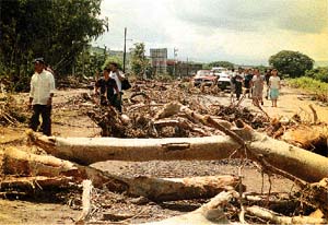
A view of what used to be the road to Sébaco, Matagalpa |
Nicaragua´s geography has changed, not only did Hurricane Mitch destroyed bridges that some will have to be rebuilt while others built some place else, but also rivers will never be the same again. |
|
Roads that used to communicate with populations are not there any more, instead huge dishes left there by the inmense water flow from the rivers. New lagoons, sand beaches, big tree extensions and diverse harvest are buried in the sand and mud left behind by the river´s currents.Mountains, volcanos and peaks show huges scratches left by the mud flows. Barrios, pueblos and cities that now remain only in people´s minds. Lake Xolotlán -close to Managua- still remains only few meters away from the main streets of San Francisco del Carnicero and it continues to advance. Jinotega´s "Las Playitas" lagoon was fading away, now it is so full of water that it doesn´t allow people around to harvest corn, plantains or bananas. |
|
|
This used to be the road to Sebaco. The one hundred meter partition took place exactly there. |
The view in the northern part of the country is hard to believe. Only if you actually travel there can one get an idea of what really happened there. When you see those huge trees over the road in the midst of mud the only thing the comes to mind is the tremendous force that put them there. In Sébaco the river cut over hundred meters of road. Now a provisional road has taken the place, but it was that huge partition that cut all communication to five provinces in the north. |
|
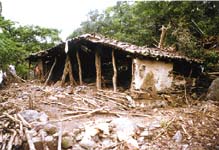
Ghost-like town is what Terrabona -a pueblo from Ciudad Dario- looks like today. |
Some pueblos in far away areas in the north part of the country seem ghost like towns. Some have lost all its houses and in the middle of the mud you can see all type of objects brought there by the river currents. |
|
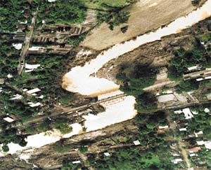
This is Ciudad Darío splitted by the current that killed many and destroyed hundres of houses leaving thousand homeless. |
|

![]()